As Superstorm Sandy hits the Northeast of the United States, some University students are keeping up with family members who are in the midst of the storm.
Sandy is a hybrid storm, which is a combination of a tropical cyclone and a cyclone formed outside the tropics, said Barry Keim, geography and anthropology professor and state climatologist.
Sandy will develop the worst characteristics of both types of storms, including a storm surge along the East Coast of 10 to 12 feet. Keim said the surge will range from central New Jersey to southern New England.
Because it is has components of an extra-tropical storm, Sandy will cover some areas of the nation with snowfall. In the mountains of West Virginia, he said there could be snowfall of two to three feet in some places.
Some of Louisiana’s recent cold weather is linked to the storm, Keim said.
Another characteristic that makes Sandy different from other storms is its track. He said Sandy’s path and size differentiates it from the 160-year record of hurricanes. This means that there is greater uncertainty as to her impact.
Sandy’s track is unique to the region, Keim said.
Hybrid storms often occur during the latter part of October because the sea waters are still warm enough to produce strong storms. As the waters cool off, storms are less likely to form, he said.
Keim said Sandy will only last for a couple of days, but it will “rough up” the eastern coast of the nation.
Families in the Northeast stocked up on food and water in preparation for Sandy and bunkered down in their homes.
Communication disorders senior Jessica Griffin is from Haworth, N.J., and said her family loaded up on food and water because it was projected their power could be out for a week. With the high wind speeds, she said it’s possible tree limbs could knock out the power, which is what her family is concerned about.
“Right now they’re less worried about the actual rain, and more worried about the power going out,” Griffin said.
If the power goes out, she said her family has a gas fireplace and a generator.
French junior Kelsey Gibree said her stepfather, mother and stepbrother prepared for Sandy at their home in Auburn, Mass., by making sure they had an adequate supply of wood for their woodstove for heat. She said the weather in Massachusetts was cold and the state could get some snow in the next few days.
She said her family is not expecting the weather to be unmanageable because they have experienced rough weather from blizzards.
“They’re really not too worried,” she said.
Griffin said her cousin works for ABC News in New York City, and because mass transit systems shut down at 6 p.m. Sunday, he was staying in a hotel throughout the storm without his wife and children.
Griffin said her father, who is a volunteer fireman, had to stay in the firehouse in case of electrical fires or trees falling in the road.
“I was just thinking, I’ve had my first hurricane, and now home is getting their first hurricane,” she said.
Because she endured a storm herself, Griffin said she was able to tell her family what to do to prepare for Sandy. She told them to buy extra water and canned foods, and also to fill their bathtubs with water.
“I told everyone to keep their phones fully charged,” she said.
After experiencing Hurricane Isaac in late August to early September, Gibree said she is not too worried about Sandy. She said she knows her family can take care of itself.
-
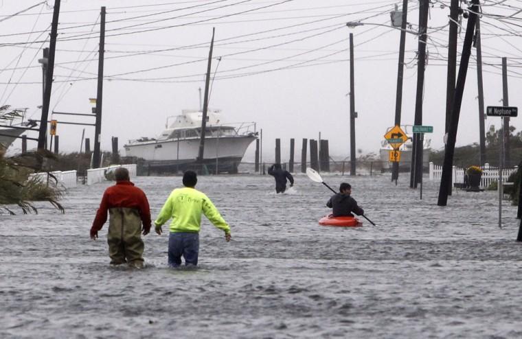
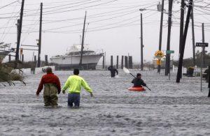
People wade and paddle down a flooded street as Hurricane Sandy approaches, Monday, Oct. 29, 2012, in Lindenhurst, N.Y. Gaining speed and power through the day, the storm knocked out electricity to more than 1 million people and figured to upend life for tens of millions more. (AP Photo/Jason DeCrow)
-
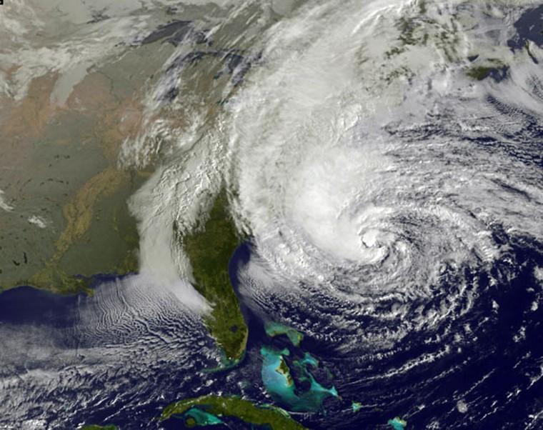
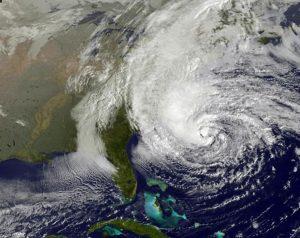
This NOAA satellite image taken Sunday, Oct. 28, 2012 shows Hurricane Sandy off the Mid Atlantic coastline moving toward the north with maximum sustained winds of 75 mph. Tens of thousands of people were ordered to evacuate coastal areas Sunday as big cities and small towns across the U.S. Northeast braced for the onslaught of a superstorm threatening some 60 million people along the most heavily populated corridor in the nation. (AP Photo/Weather Underground)
-
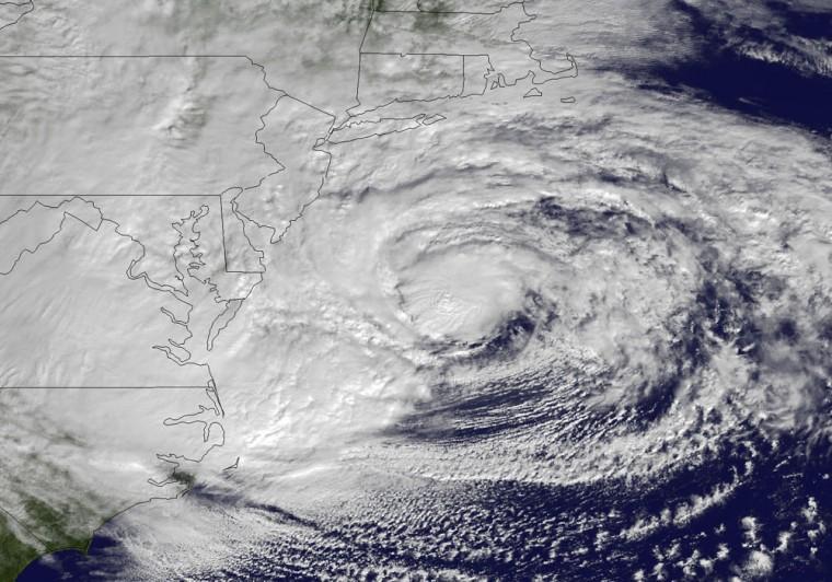
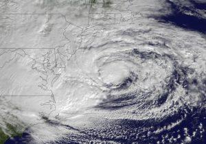
This NOAA satellite image taken Monday, Oct. 29, 2012 shows Hurricane Sandy off the Mid Atlantic coastline moving toward the north with maximum sustained winds of 90 mph. Hurricane Sandy wheeled toward land as forecasters feared Monday, raking cities along the Northeast corridor with rain and wind gusts, flooding shore towns, washing away a section of the Atlantic City Boardwalk, and threatening to cripple Wall Street and New York’s subway system with a huge surge of corrosive seawater. (AP Photo/NOAA)
-
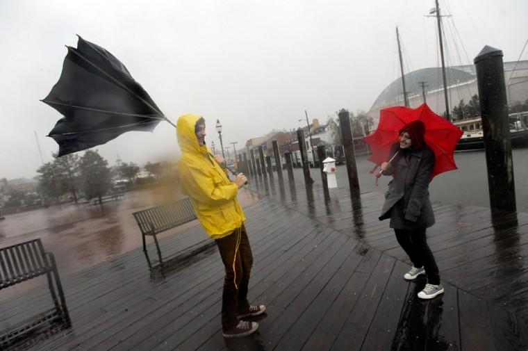
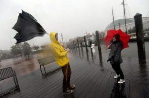
Jake Wilkerson, 20, and Kaityln Baker, 21, both of Annapolis, Md., struggle with their umbrellas as Hurricane Sandy approaches Annapolis Monday, Oct. 29, 2012. Hurricane Sandy continued on its path Monday, as the storm forced the shutdown of mass transit, schools and financial markets, sending coastal residents fleeing, and threatening a dangerous mix of high winds and soaking rain. (AP Photo/Steve Ruark)
-
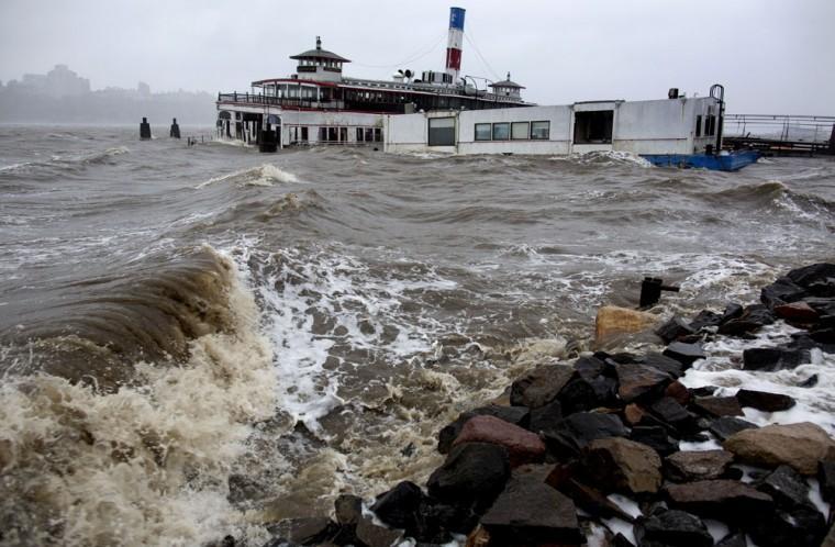
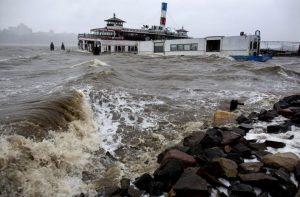
An historic ferry boat named the Binghamton is swamped by the waves on the Hudson River in Edgewater, N.J., Monday, Oct. 29, 2012 as Hurricane Sandy lashed the East Coast. As it drew near, Sandy moved closer to converging with two cold-weather systems to form a superstorm of snow, rain and wind. Forecasters warned of 20-foot waves bashing into the Chicago lakefront and up to 3 feet of snow in West Virginia. (AP Photo/Craig Ruttle)
-
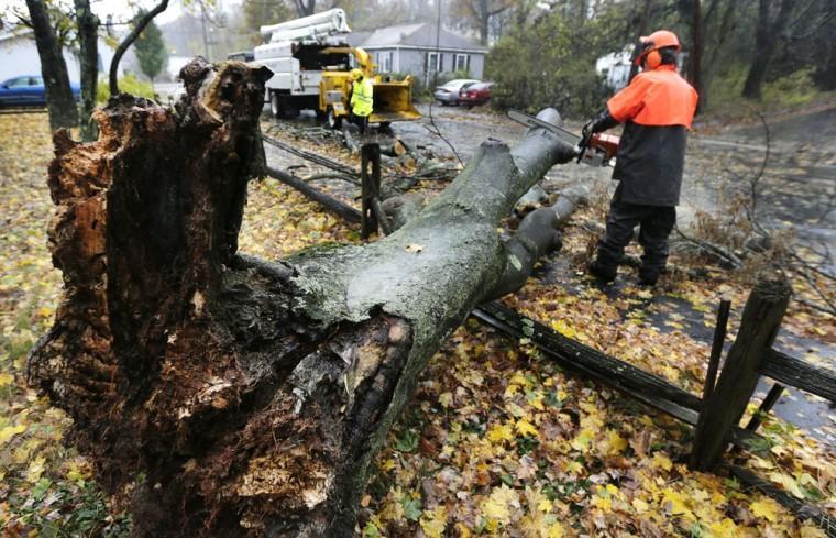
A worker clears a tree dropped by the high winds prior to landfall of Hurricane Sandy in Shrewsbury, Mass., Monday, Oct. 29, 2012. Hurricane Sandy continued on its path Monday, as the storm forced the shutdown of mass transit, schools and financial markets, sending coastal residents fleeing, and threatening a dangerous mix of high winds and soaking rain. (AP Photo/Charles Krupa)
-
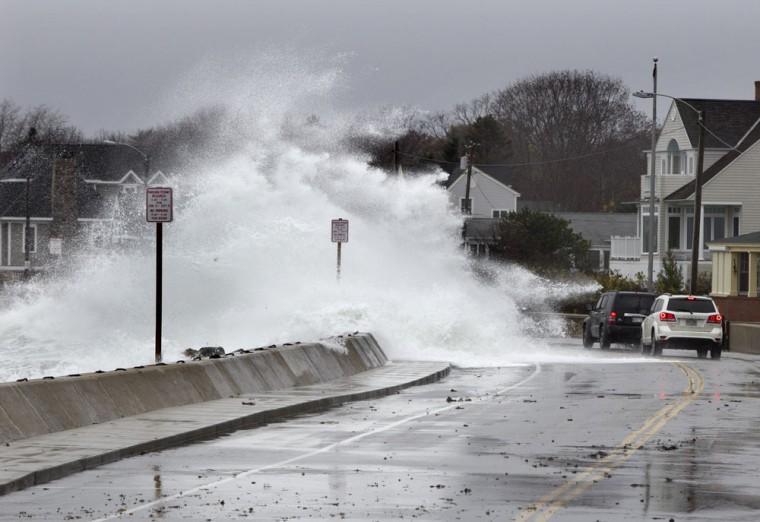
Heavy surf crashes over a seawall on the Atlantic Ocean during the early stages of Hurricane Sandy, Monday, Oct. 29, 2012, in Kennebunk, Maine. Hurricane Sandy wheeled toward land as forecasters feared Monday, raking cities along the Northeast corridor with rain and wind gusts, flooding shore towns, washing away a section of the Atlantic City Boardwalk, and threatening to cripple Wall Street and New York’s subway system with a huge surge of corrosive seawater. (AP Photo/Robert F. Bukaty)
-
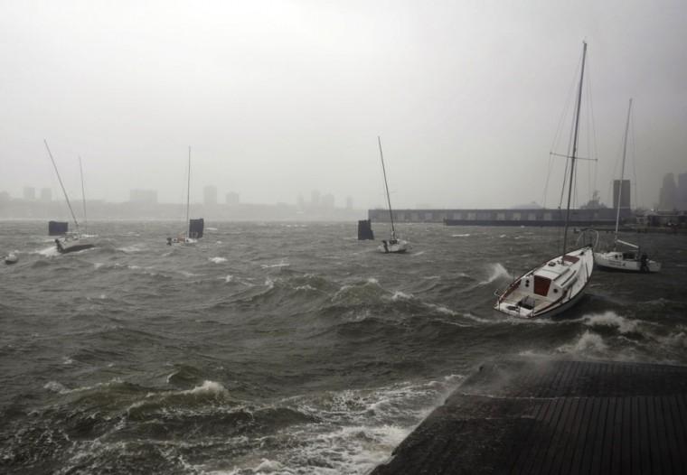
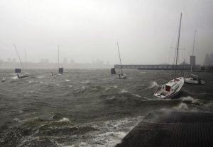
Sailboats rock in choppy water at a dock along the Hudson River Greenway during a storm, Monday, Oct. 29, 2012, in New York. Hurricane Sandy continued on its path Monday, forcing the shutdown of mass transit, schools and financial markets, sending coastal residents fleeing for higher ground, and threatening a dangerous mix of high winds and soaking rain. (AP Photo/Jeffrey Furticella)
-
People wade and paddle down a flooded street as Hurricane Sandy approaches, Monday, Oct. 29, 2012, in Lindenhurst, N.Y. Gaining speed and power through the day, the storm knocked out electricity to more than 1 million people and figured to upend life for tens of millions more. (AP Photo/Jason DeCrow)
-
This NOAA satellite image taken Sunday, Oct. 28, 2012 shows Hurricane Sandy off the Mid Atlantic coastline moving toward the north with maximum sustained winds of 75 mph. Tens of thousands of people were ordered to evacuate coastal areas Sunday as big cities and small towns across the U.S. Northeast braced for the onslaught of a superstorm threatening some 60 million people along the most heavily populated corridor in the nation. (AP Photo/Weather Underground)