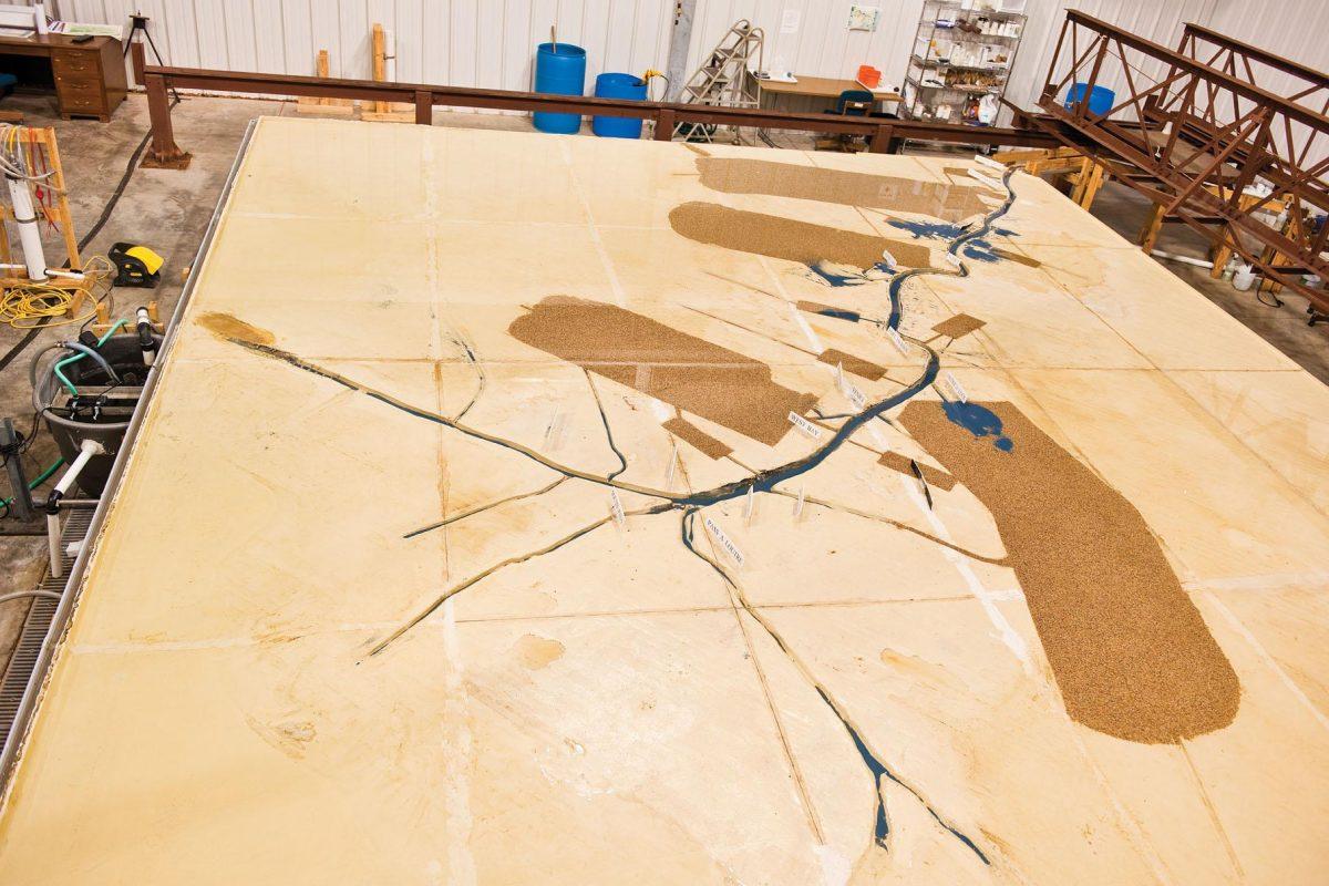
In a steel warehouse on River Road, Josef Hoffmann is controlling the flow of the Mississippi River.
It’s not the real thing, but it’s probably the closest the civil engineering master’s student can get to controlling the real river.
Hoffmann is working on a sprawling reproduction of a 76-mile length of the Mississippi River Delta that stretches from Myrtle Grove, about 20 to 30 land miles south of New Orleans, to Southwest Pass, where the river reaches the Gulf of Mexico.
“Yeah, it’s pretty exciting,” Hoffmann said, pointing to the “headbox,” where the engineering students who work on the model regulate the flow of water into the system.
Hoffmann is one of several graduate and undergraduate students who work on the model, which he said provides valuable data for research into preventing coastal erosion.
The model itself is a huge, flat tan table covered in a thin film of water. The mini-Mississippi snakes through a landscape of brown gravel, into which various trenches have been carved out like branches from the veiny main river.
The entire assembly is ringed with a gutter, and the water flows right back into the system after dripping off of the simulated swamps.
A walkway on rails stretches above the model so Hoffmann and his coworkers can get a bird’s eye view.
The grit used to simulate the sediment flows down the river, staining the areas near the diversions a bright blue — the vibrant color is designed to stick out so the researchers can easily see where the sediment is going.
In the effort to preserve Louisiana’s disappearing coast, engineers divert the river, allowing sediment to flow out, build up and buttress the surrounding land. The model allows researchers to test different locations for these diversions.
Hoffmann said he and colleagues measure two results from the diversion tests — the amount of sediment dispersed in the surrounding area and the effect the diversion will have on dredging requirements downstream.
The U.S. Army Corps of Engineers is constantly dredging near the river’s mouth. Diversions affect the amount of sediment that makes it downstream, which would reduce the amount of dredging necessary.
In most instances, the students test two different diversion scenarios and measure the sediment displacement each test causes.
Each test takes about 30 minutes and simulates approximately two years of river flow.
Hoffmann said the experiments are practical, but they can’t say for certain the sediment will behave exactly like the blue grit in the model.
“It’s not quantifiable, but we can tell which option is better,” he said.
The model is carefully calibrated to represent the river as closely as possible.
White placards dot the river at regular intervals, bearing names like “South Pass” and “Head of Passes.” These placards correspond with points on the real river where the Corps measure water depth.
The students constantly check the depths on the river model against the depths on the real river.
“That way we know that our river, hydrologically at least, is equivalent to the real thing,” Hoffmann said.
Ideally, the model’s sediment depth would be compared to the real river’s sediment depth, but because measurements are hard to come by in the real world, Hoffmann said the hydrological measurements are the next best thing.
But for the model, measuring and manipulating the sediments at the river bottom is feasible. Part of the routine maintenance on the river includes adjusting the sediment levels based on dredging reports by the Corps.
The experiments conducted using the model are funded by agencies looking to test the effects of proposed diversions, trenches and other river modifications.
The agencies provide funding to hire the students necessary to run the experiments. Those students gain valuable hands-on experience performing the tests to simulate the agencies’ proposed work.
The original funding for the project and the warehouse that houses it was provided by the Louisiana Department of Natural Resources.
The project’s total construction cost was close to $650,000, according to a news release from the project’s opening. That includes the costs of data collection, design, construction and shipping as well as the building housing the model.
—-
Contact Matthew Albright at malbright@lsureveille.com
Students use model of Mississippi River for research
August 31, 2010


