

“It’s weird watching something that you know you’ll never see again,” said Coastal and Environmental Sciences Professor Paul Miller. “I’ll be dead before this happens again, and the last time anything remotely similar to this happened in Louisiana, all of those people are now dead.”
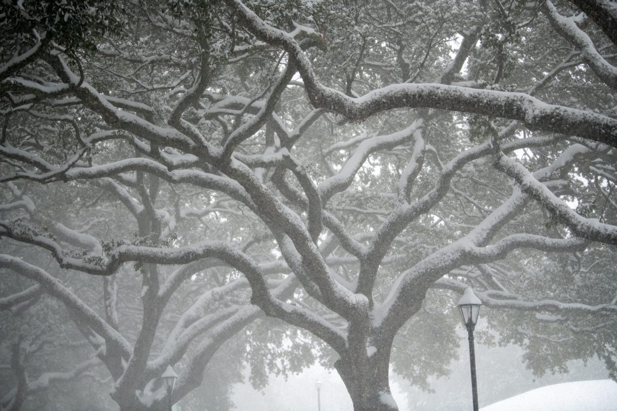
Baton Rouge residents woke up to an astonishing sight on Tuesday, Jan. 21: a record-breaking 7.6 inches of snow blanketed the city overnight. This rare winter event shattered historical records and left meteorologists marveling at the nearly impossible conditions that had to align for such a phenomenon to occur.
Snow in Baton Rouge is an extremely rare event, having been recorded only 23 times since 1893. Typically, it results in a light dusting of snow or a short-lived event that lasts for a couple of hours. The fact that the most recent snowfall accumulated to such an extent made it an even more extraordinary occurrence.
“Any given year you have about a 17% chance of this happening,” said Chief Meteorologist for WBRZ Josh Eachus. “This was a record event for our area. It took 120 years for this to happen.”
What made this storm so unique was the perfect alignment of cold air and a gulf storm system. When arctic air pushes this far south, it usually dries out the atmosphere, preventing snow. However, in this case, a storm system tracked across the central Gulf of Mexico, providing just the right amount of moisture without introducing warmer air that would have turned the snow into rain.
This alignment is what Miller referred to as a ‘Goldilocks zone,’ the perfect combination of cold air and storm track. If the system had been farther north, it would have resulted in rain. If it had been farther south, the region would have stayed dry. The alignment of these factors made this snowfall a once in a generation event.
“You know that saying that if you have a bunch of monkeys in a room with a typewriter, they’ll eventually write Shakespeare,” Miller said. “To me, this event was that. If you ever happen to be in the room when the monkey writes Shakespeare you’ll be like, ‘Oh my God. We witnessed something that is an alignment of so many perfect circumstances that might happen again, but not while I’m alive.’ So you have to sit back and be like, ‘Wow, I was there when that happened.’”
Before this storm, Baton Rouge had only recorded more than 3.5 inches of snow five times in the last 130 years. This event also coincided with the second-lowest temperature ever recorded in the city. The statistical rarity of such a snowstorm makes it unlikely that a similar event will happen again anytime soon.
Social media buzzed with excitement as many residents marveled at the sight of snow-covered rooftops and streets. Unlike other extreme weather events Louisiana typically experiences, such as hurricanes, this snowfall brought joy rather than destruction.
“Since when have you had an extreme weather event in Louisiana that just makes everyone happy?” Miller asked.
Despite speculations on social media, Eachus and Miller say that forecasts indicate that another snowfall event is unlikely in the near future. February is expected to trend averagely warmer, with some temperatures reaching above 80 degrees Fahrenheit. While this event was historic, it does not signal a shift in Louisiana’s winter climate patterns, and it’s too early to tell if it’s a sign of climate change’s impact on Louisiana.
“It takes years for patterns to emerge to try to say what role this event may have played one way or another,” Eachus said when asked if this event is an indication of climate change. “You kind of have to let these things play out and then look back in time. Say this is something we see happen more often in the next 10 or 20 years then, we might be able to start saying, yeah, that 2025 event was an early indication of shifting patterns, but it’s hard to assess it right after the fact.”
The snowfall of Jan. 21, 2025 will remain a memorable event for those who witnessed it, marking a rare moment when Baton Rouge transformed into a winter wonderland, if only for a day.