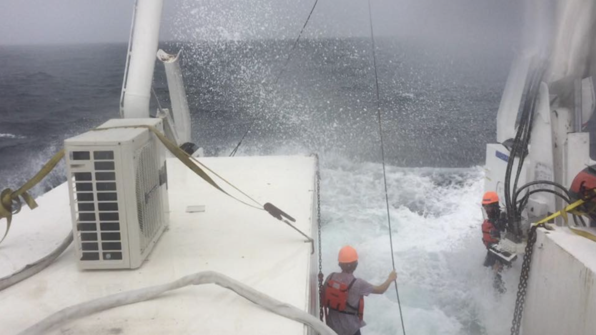


The 59th day of the Gulf oil spill catastrophe also marks the 17th day of this year’s hurricane season in the region, forcing government and BP officials to devise alternate response plans for a worst-case scenario and talking pundits to speculate about a storm’s effects on the oil.Barry Keim, Louisiana state climatologist, said this year is on track to be the second-busiest hurricane season, with the National Weather Service predicting between 14 and 23 named storms in the Atlantic Basin. The busiest season since 1851, the year records start, was 2005, which had 28 named storms. The National Weather Service predicts eight to 14 of those storms will develop into hurricanes this season, with between three and seven being “major hurricanes,” which are Category 3 or greater. The Atlantic hurricane season, which includes the Gulf of Mexico, runs from June 1 to Nov. 30, according to the National Hurricane Center. The Pacific hurricane season starts May 15 but ends at the same time as in the Atlantic.Keim, who also works in the Department of Geography and Anthropology, said oil creates warmer water temperatures, which are conducive to hurricane formation, but the spill will not “significantly affect the development of storms,” but rather the storms will greatly impact the response efforts. “A hurricane would distribute [the oil] further and wider across the Gulf and obviously affect more people,” Keim said, noting the effects could vary widely depending on a hurricane’s size and direction. “But dispersing it, on the upside, may help it break down a bit more quickly.”Chris D’Elia, dean of the School of the Coast and Environment, echoed Keim’s sentiments. He said a hurricane could be somewhat beneficial in helping the oil disperse and break down, but it could also be harmful by pushing oil further inland into rivers and estuaries. In a June 14 daily update, Federal On-Scene Coordinator Rear Admiral James Watson said BP is following the federal government’s direction to “move more quickly” and outlined a plan to contain more than 50,000 bpd by the end of June. This plan also better allows the response efforts to deal with “bad weather or unforeseen circumstances,” such as a hurricane.Keim said BP may have to stop efforts at the well site, like drilling the relief wells, if storms come near the rigs. The booms being used to stop oil from spreading “just won’t be able to work when you’re talking about waves of 25, 50 and even 75 feet high that far out in the Gulf,” Keim said. The sand berms being constructed across the Louisiana coast may also fail if large waves top the berms.Joseph Suhayda, interim director of the LSU Hurricane Center, said warmer-than-average surface water temperatures and the La Nina wind conditions contribute to this year’s busy season. Last year, the El Nino weather pattern helped reduce the potential of storms to form. Only nine named storms formed during the below-average 2009 Atlantic hurricane season, and three intensified into hurricanes, two of which were a Category 3 or stronger, according to the National Weather Service. “The booms are going to be just like any other debris floating around,” Suhayda said. “We could also see a lot more movement of that oil-laden water washing into the inland parishes and places like Lake Pontchartrain.”Keim said July 3 is the average date of the first named storm in the Atlantic basin. In 2005, the busiest year on record, the first named stormed developed June 8.Dennis Feltgen, a spokesman for the National Hurricane Center in Miami, said a tropical wave in the Atlantic that at the beginning of the week was likely to develop into a storm “ran into some problems Tuesday,” and now has only a 10 percent chance of developing further by Friday. Dry-air intrustion and a wind sheer from the south stalled the tropical wave’s ability to develop into a storm.Feltgen said the National Hurricane Center will continue to monitor the tropical wave despite its unlikely chance of further development, as well as closely following a tropical depression in the Eastern Pacific off the coast of Mexico. Suhayda said a storm could also move large portions of oil off the water’s surface and into the water column. This oil could then form tar balls, which are susceptible to wave movement and easily wash on shore. Hurricanes coming to Louisiana from the south, he said, often push water to the west and to the north, as Hurricane Katrina did.”If we get the strong waves associated with a hurricane, it can reach down there, pick up that stuff that would otherwise be in a quiet area and move it ashore,” he said. “You could expect that the eastern side of Louisiana will get a lot of flooding, and the flood waters do penetrate into the estuaries.” Keim encouraged students to be familiar with hurricane evacuation routes and to stock supplies like batteries, candles, water and nonperishable foods.”We’ve been hit here in Louisiana during some quiet seasons as well as during active seasons,” he said. “We always need to be on the ready, and we’ll just have to wait and see how a storm will actually impact the oil spill.”–Contact Nicholas Persac at [email protected]
Hurricane season storms could stall oil response efforts, help oil disperse
June 16, 2010
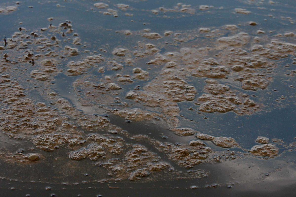
A patch of oil floats Monday on the water near the coast of Grand Isle.
More to Discover