


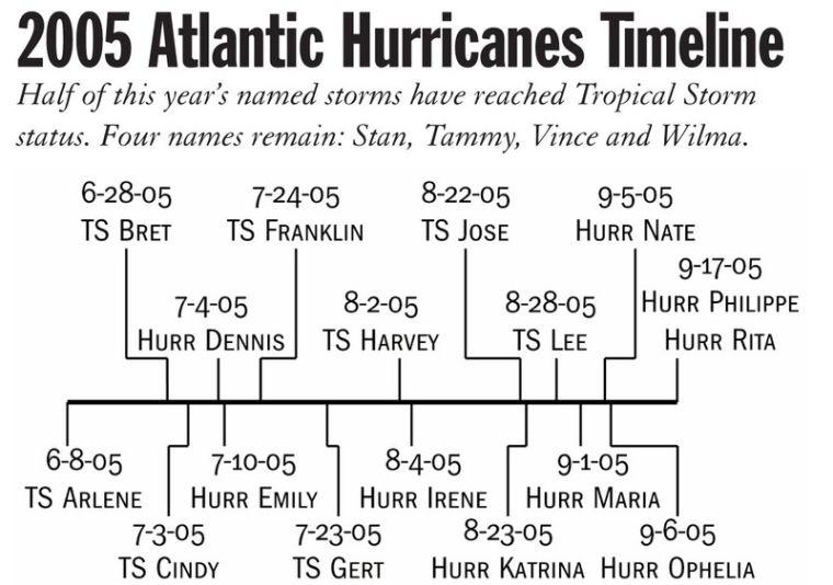
The World Meteorological Organization may resort to naming hurricanes as Greek letters this season because there are only four names left for use on the 2005 list of hurricane names.
Hurricane Rita took the 17th name on the Atlantic Ocean list on Sept. 24, and the hurricane season does not end until November. An international committee of the WMO decides the 21-name lists for hurricanes five years before to a hurricane season. There are separate lists for each area of the world prone to hurricanes, according to the National Hurricane Center Web site.
Phil Klotzbach, research associate in the department of atmospheric science at Colorado State University, said hurricanes were not named until 1950, and forecasters used Air Force codes until 1953, when hurricanes received female names. They began using male names in 1979. Hurricane name lists in other areas around the world include words in various languages, Klotzbach said.
William Gray, professor in the Department of Atmospheric Science at CSU, has put out hurricane forecasts since 1984, using indicators like temperature and sea level pressure. Gray, Klotzbach and other researchers study the past 50 seasons and isolate seasons that had similar temperature, air pressure and other conditions to make a comparable prediction for the next season.
“The ocean is usually predictable, but the atmosphere sometimes doesn’t respond well,” Klotzbach said.
Hurricanes form when ocean water temperatures are at least 80 degrees Fahrenheit, winds in the upper level of the atmosphere are weak and a pre-existing area of lower pressure exists, which is usually caused by thunderstorms or other types of bad weather, said Robert Howard, assistant professor of atmospheric science at the University of Louisiana-Monroe. Howard said he equates the accuracy of predicting hurricanes to throwing darts.
Klotzbach said the temperature in the Atlantic Ocean has been warmer since 1994, a trend due to the ocean’s circular patterns that will last 25 to 35 years.
“Since 1995, the ocean’s been really toasty, with larger hurricanes,” Klotzbach said.
Howard said hurricanes form most commonly from tropical waves from the African coast that travel to the Gulf of Mexico, like Hurricane Katrina. Howard said Katrina and Rita came to Louisiana because of a large, high pressure “ridge” of hot air that is centered over north Louisiana, which is a conducive atmosphere for attracting a major hurricane. But Howard also said the ridge will be moving soon, which may draw hurricanes away from the coastal areas of the Gulf of Mexico. High pressure areas over land attract hurricanes to the coastal areas, Howard said, while low pressure areas over land push them back into the ocean where they can come in contact with islands.
Klotzbach said the hurricane season is waning, so the WMO may not have to turn to Greek names.
“Climatologically, it’s about 80 percent done,” Klotzbach said.
Contact Leslie Ziober at [email protected]
Few names remain for season’s hurricanes
September 30, 2005
Few names remain for season’s hurricanes
More to Discover