The University’s Earth Scan Laboratory received a major upgrade last week that will reduce the time it takes to process satellite data from hours to minutes.
Lab director Nan Walker said the Earth Scan Lab, or ESL, captures infrared data of the Atlantic Basin with five sophisticated satellite systems. The satellites gather data from the Gulf of Mexico, the Eastern Pacific, South America and the Hudson Bay. The data is processed and imaged in real time and is updated every 30 minutes.
Walker said the ESL is a part of the Department of Oceanography and Coastal Sciences at the School of Coast and Environment. The data they collect is used to support a number of novel projects, including research on cyclones, changes in oxygen content, water quality flooding and oil spills.
The laboratory was recently equipped with upgrades to its X-band antenna, which captures data from satellites which monitor the atmosphere and changes in temperature, moisture and pressure.
With these new upgrades, the ESL will be able to obtain data from a Visible Infrared Imaging Radiometer Suite, or VIIRS, sensor attached to the Suomi National Polar-orbiting Partnership satellite, a culmination of research and engineering conducted by NASA, the National Oceanic and Atmospheric Administration and the Department of Defense.
Walker said the satellite’s new sensors will improve the quality of ESL’s research and allow scientists to obtain and analyze data more rapidly.
“We upgraded the computer system too, so everything runs a lot more smoothly,” Walker said.
Before the upgrade, ESL’s computers could process data within a few hours of receiving it. With the new upgrade, ESL systems can now process new information in a matter of minutes.
The upgrade was installed by Tony Burnuoff of the California-based SeaSpace Corporation and Alaric Haag, the Earth Scan Lab’s systems administrator.
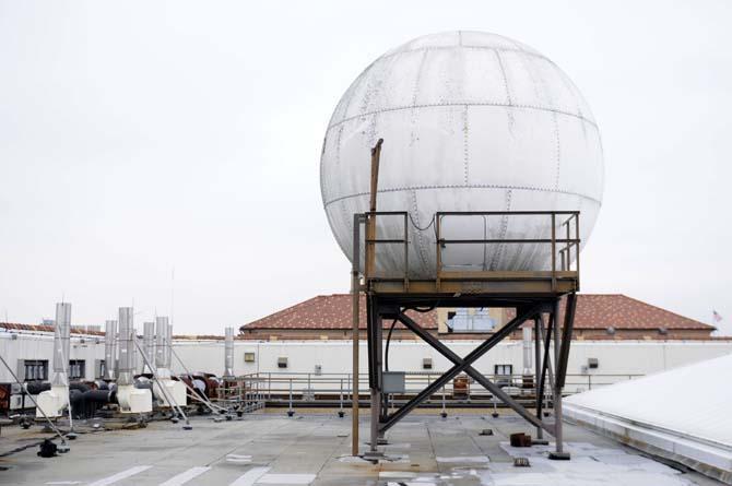
The installation began in February, and its completion was recently announced to the public. Haag traversed four flights of stairs, ascended a ladder and crawled into a protective fiberglass shell to access the satellite’s antenna, which whirred and spun as it rapidly collected new data.
Haag said the laboratory boasts some of the most cutting-edge technology in the world, and the data their satellites have collected have been used by scientists all over the world.
“Texas A&M uses our data to study dead zones without oxygen in the ocean,” Haag said.
One of the biggest roles ESL fulfills is as a monitoring station for oil spills. The satellites capture images of ocean eddies, which are often indicative of oil and gas activities in the Gulf Coast.
“BP gave us a lot of money to position LSU to be prepared with satellite data and validated coastal models for an oil spill,” Walker said.
Walker said some of this money was used to finance the new upgrade.
They also monitor changes in temperature and water current in the Gulf of Mexico.
According to Walker, the currents gain speed as they move into areas containing excessive amounts of oil and gas.
Walker said she hopes that the new upgrade will catalyze a new wave of research on tropical environments and cyclones, now that ESL has technology that enhances its ability to monitor oceanic and land-based features. They obtain much of their funding by producing quality research for climate scientists and technology corporations, and expect to receive another upgrade to the lab in the near future.
“We upgraded the computer system too, so everything runs a lot more smoothly.”
Earth Scan Lab receives important upgrade
By Panya Kroun
March 5, 2014
The visible infrared imaging radiometer suite, VIIRS, satellite sensor sits on top of the Howe Russell Geoscience complex Wednesday, Mar. 8, 2014 as it recieves information from the suomi national polar-orbiting partnership satellite currently in orbit.
More to Discover


